The database starts producing interesting results!!

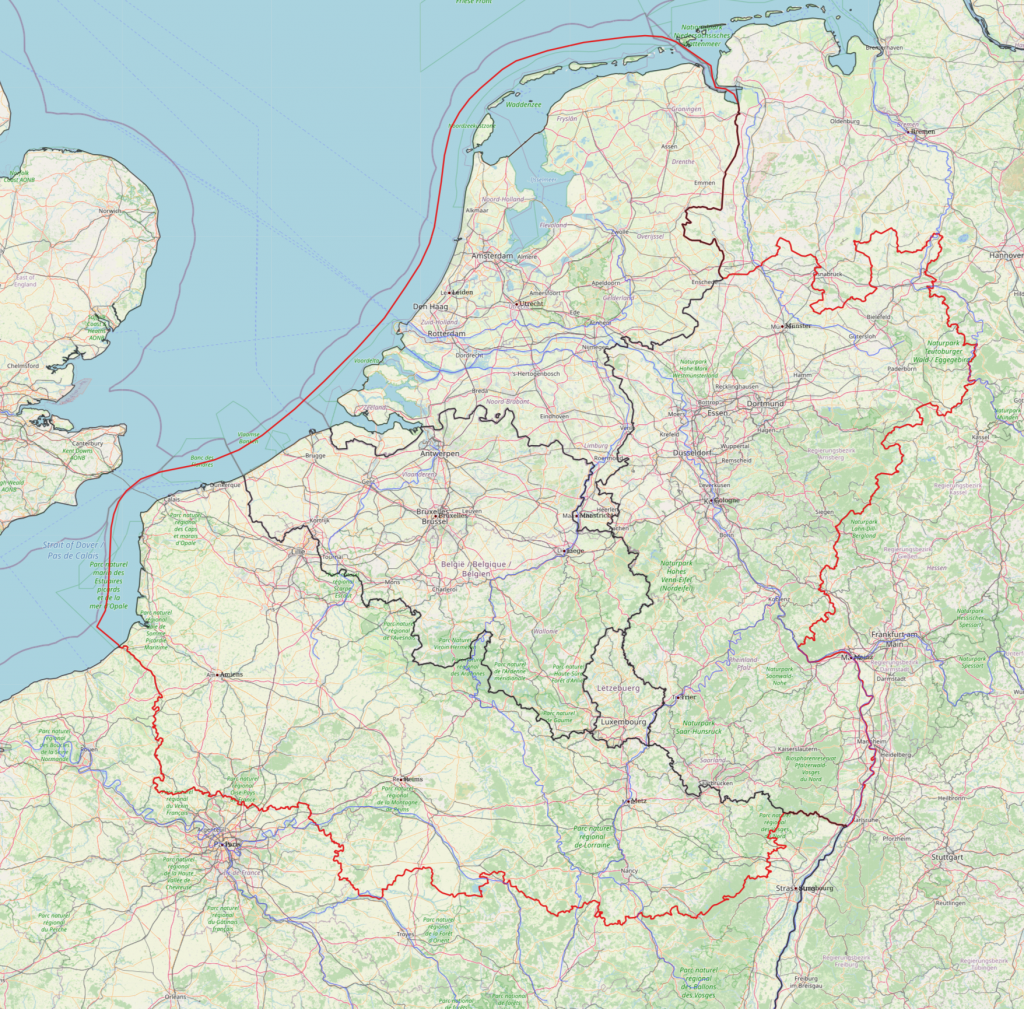
When interesting questions are asked!

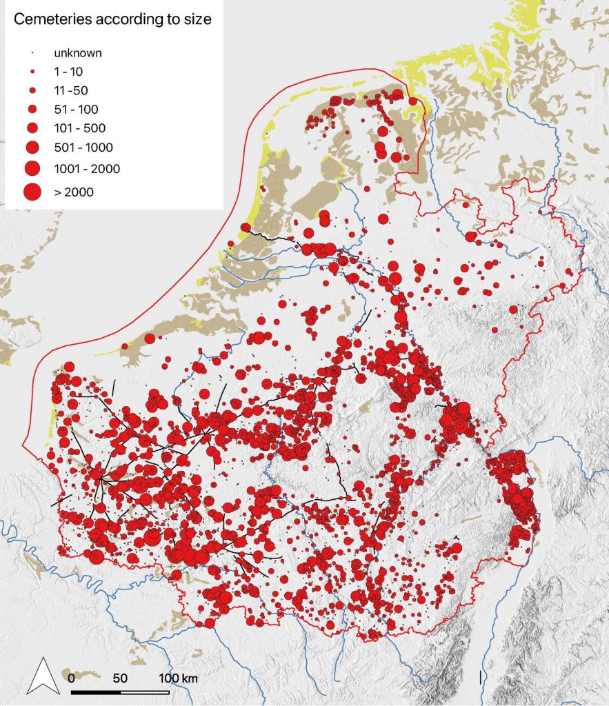
After several years of adding data to the database (not full time!) we are writing a large series of queries based on questions formulated by team members. Now gradually the potential of the database becomes visible, especially when combining evidence from various parts of the database. We started, of course by asking very basic questions such as those which allow an assessment of the quality of the database and the quality of the data. A simple question is to show the recorded cemetery sites according to the number of graves excavated/recorded. This results in the map below. In spite of the flaws inherent in the cemetery data (incomplete cemeteries, many ‘unknown’) this allows a first analysis of the distribution of the population over Northern Gaul. We will do this in relation to landscape characteristics, the remaining Roman infrastructure, the presence of rivers etc.

The distribution of cemetery sites according to size.

The quality of the data

The database also allows to analyse the quality of the data. This varies considerably over the research area and we have to consider this constantly when interpreting distribution maps. Merovingian cemeteries have been discovered already from before AD 1800 especially in France and in areas where stone sarcophagi and stone built graves were discovered while reclaiming land or ploughing fields. Cemeteries discovered in the 19th century were usually ‘explored’ rather than ‘excavated’. The goals of the exploration (adding to museum collections or providing the antiques market) will have determined to a large extent what was collected. The map below shows the cemeteries discovered before the First World War. Most of them were subject to exploration and limited documentation.

Cemetery sites discovered before the First World War.

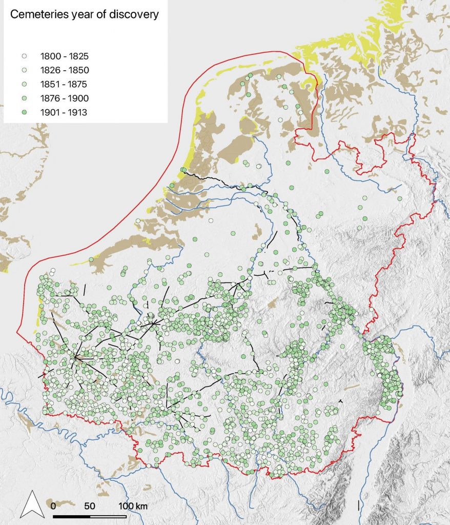
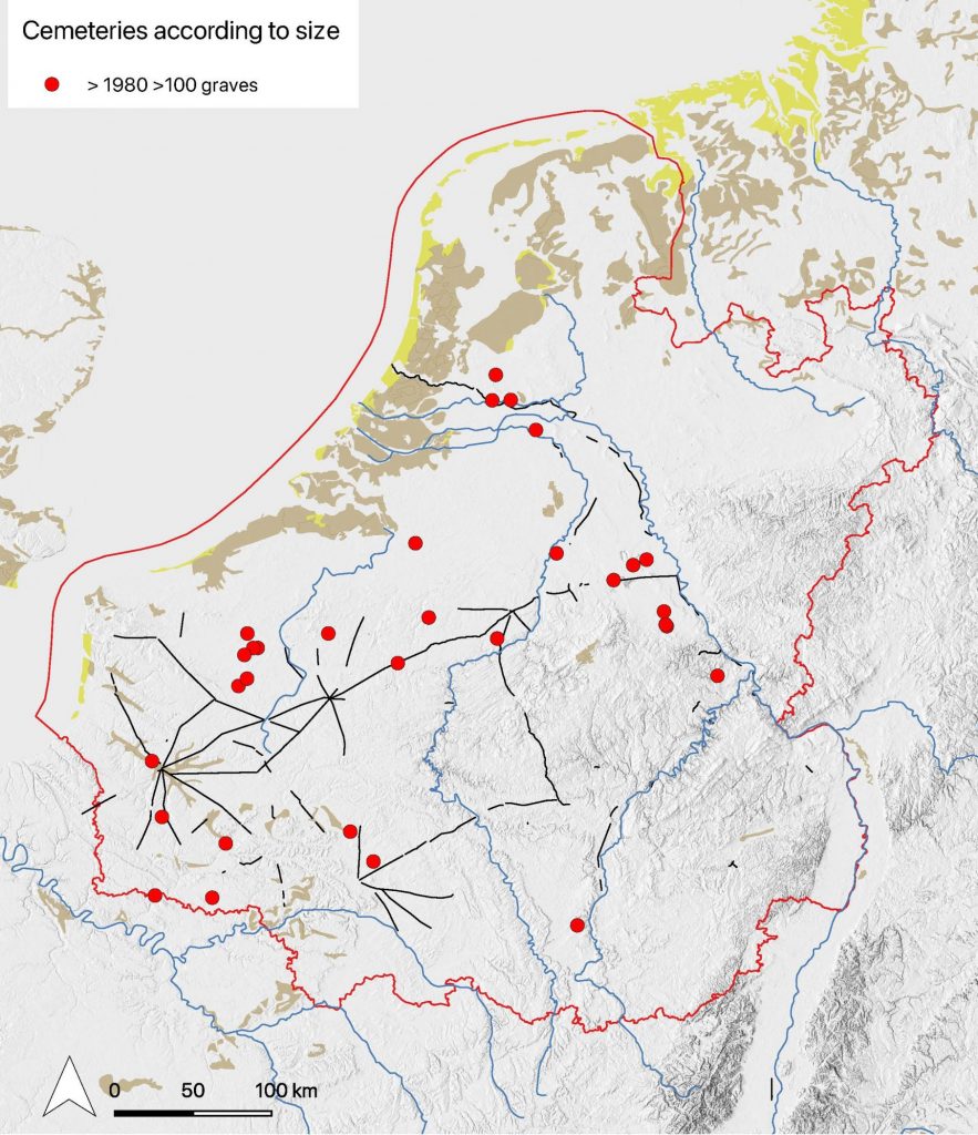
When one compares this image with the one of the distribution of cemeteries discovered only after 1980 that are larger than 100 graves, that is those which have been excavated (and published) in a modern way one can see how limited the availability of high quality data is.
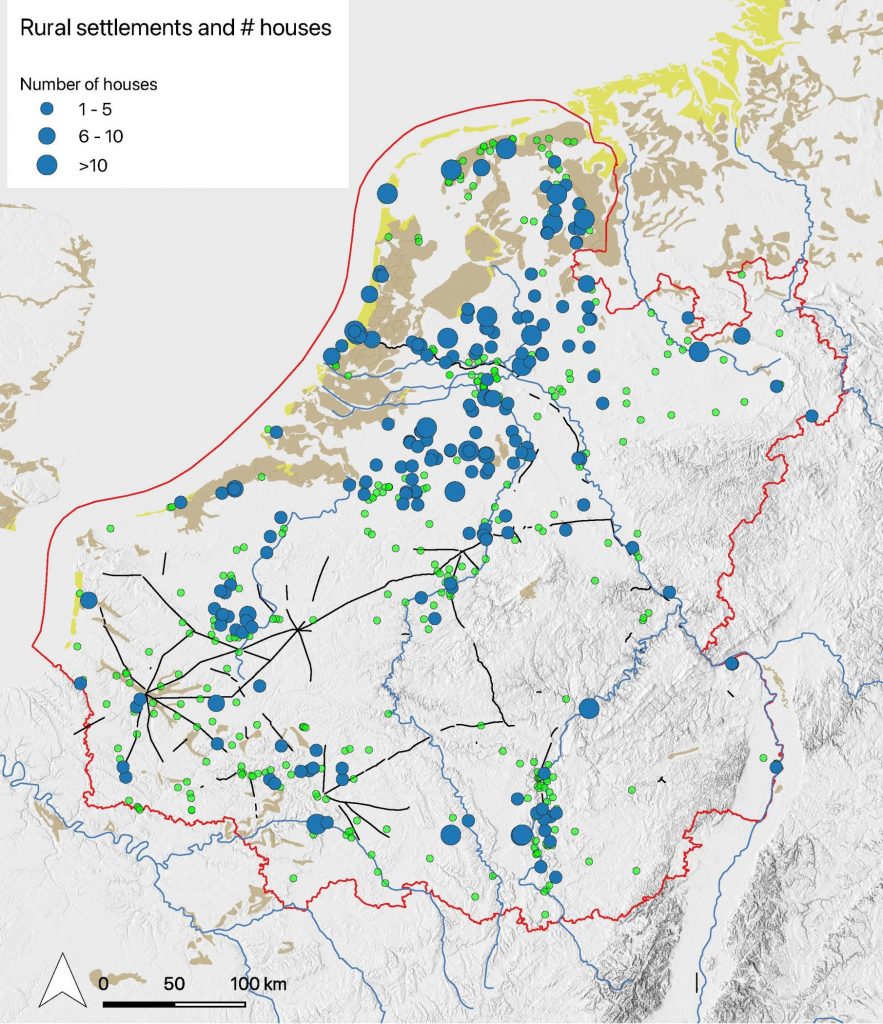
Cemetery sites discovered after 1980 with more than 100 graves.

Rural settlements

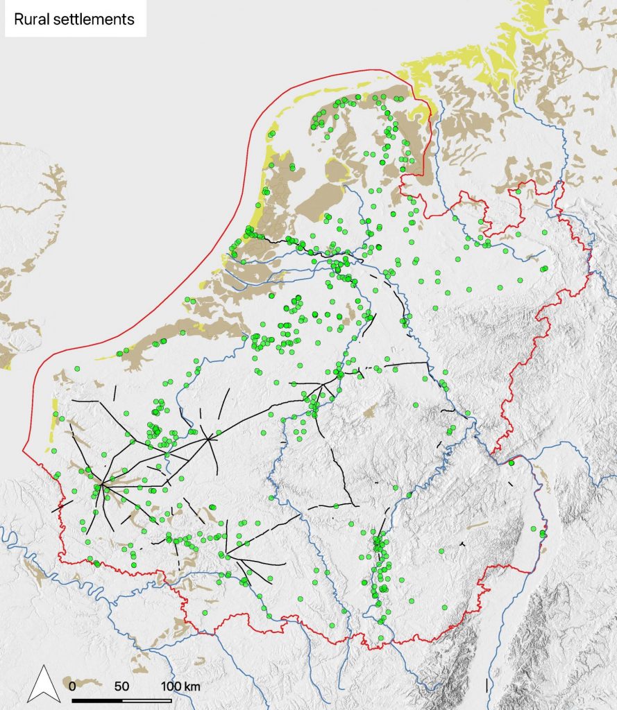
The distribution of excavations of rural settlements shows also very interesting regional differences. Many excavations of Merovingian settlements, including large scale excavations took place in the Netherlands and France, much less in Belgium and Germany (the data for Westphalia are not yet up to date). This aspect has to be studied in greater detail for the evidence from France is often not easy to interpret. It is difficult to reconstruct houses and other buildings and date them to the Merovingian period in the southern part of the research area. That can be seen on the second map where the number of recorded houses is shown. It rather shows the state of research and the size of excavated areas than the actual presence of houses of course!

Excavated rural settlement sites

Rural settlements and number of excavated houses

These are just a few (very basic) examples of using the data in the Rural Riches database. We are experimenting with more complicated questions regarding the distribution of many types of beads as proxies for exchange systems, the relation with other types of finds (brooches), the impact of concentrations of populations on the availability of certain goods, the development of population, the relation of the distribution of certain goods and infrastructural elements such as Roman roads, towns and major rivers, etc. etc. These are all in fact traditional qualitative research objectives. The database allows to quantify the data in terms of absolute numbers and relative numbers. Some experiments with the quantitative distribution (of glass vessels for instance) shows that a relative distribution can be quite different from the absolute distribution of glass vessels.

What else?

These analyses on a macro-scale form only part of the total project objectives. Research of the burial rites, the organisation of food production, the organisation of craft production, the whereabouts of Merovingian kings and aristocrats and the presence of the ‘Church’ are other aspects that will be reported on in upcoming blogs.

A new book on riverine settlement in the Western Netherlands

From 2009 until 2014 the University of Leiden excavated a settlement dating to Merovingian times. Smaller parts of the settlement had already been excavated by ARCHOL and ADC-Archeoprojecten. The Oegstgeest settlement has been excavated almost completely. It existed between c 550 and 725 AD. It was of a modest size, counting c 5 or 6 contemporary farmsteads during its existence. Its population will not have been larger than c 60 persons. Nevertheless, the finds show it was intimately connected to regions far beyond its immediate horizon such as the middle Rhine valley from which products were brought to the settlement and England from which metal finds originate. An exceptional mind blowing find was a silver bowl decorated with gold leave images, found in a gully, which embellishes the cover of the book.

No less interesting and providing a window on the connections of the inhabitants of the settlement are the finds of grape pips, the oldest shoes with soles found in northwestern Europe made of vegetable tanned leather (a Mediterranean technique), horse gear with parallel finds in England only, sword fittings with direct parallels to those in the Staffordshire hoard, pottery from the Rhine valley and grain from löss areas, probably the Main area and wine (barrels) from the middle Rhine area as well. The inhabitants must have known a varied life style including keeping cattle in the floodplains, some agriculture on the river levees, fishing, and probably trading at short and long distances. They also practiced crafts such as smithing and above all casting of copper alloy objects. Small and unexpectedly large crucibles show that this must have taken place to satisfy the needs of themselves and those in other settlements.

Oesgtgeest is a truly riverine settlement, dependent on the river in the Rhine estuary, which was certainly a friend to the inhabitants. But it was a foe as well. There must have been a constant fight against the water to prevent flooding. Extensive dam building testifies to this struggle. Recent dendrochronological research allows now to even date these floodings exactly by year. 602 was a catastrophic year in the coastal areas of the Netherlands and northern Germany.

The Oegstgeest settlement will play a significant role in forthcoming discussions on the economy of northwestern Europe and the role of control of exchange values compared to control of production which dominates the discussion up til now.

The book design and lay out was in the experienced hands of Bregt Balk.

De Bruin, J./C. Bakels/F. Theuws (eds.), 2021: Oegstgeest. A riverine settlement in the early medieval world system, Bonn. Habelt Verlag (ISBN 978-3-7749-4291-2, 575 pp.)

The book can be purchased online at the website of the publisher Habelt (scroll down).

The large cemetery of Broechem published

Yesterday, December 14 2018, the publication of the large cemetery of Broechem near Antwerp was presented in Brussels. Rica Annaert and her team invested many years of research resulting in two large volumes with an analysis of the cemetery and an extensive catalogue presenting in detail the evidence on each grave. The analysis is characterized by a truly interdisciplinary approach. This cemetery will be one of the key sites for the study of Merovingian society in Flanders and the southern Netherlands. Rica Annaert pointed out herself that the present analysis, although already extensive, is only the start of exploiting the research potential of this site. 

Annaert, R., 2018: Het vroegmiddeleeuwse grafveld van Broechem/The early medieval cemetery of Broechem, Volume 1 Analyse/Analyses, volume 2 Catalogue, Habelt Verlag, Bonn. (Merovingian Archaeology in the Low Countries, 300 and 594 pp respectively)

Rica Annaert presenting the Broechem cemetery in Brussels

The Rural Riches project research area

The Rural Riches project focusses on northern Gaul. Northern Gaul in Merovingian times distinguishes itself from central and southern Gaul in several respects. One of them is the general presence of a lavish burial rite resulting in thousands and thousands of graves with abundant grave goods in women’s and men’s graves. Further south lavish burial is present but less common. Another characteristic of Merovingian northern Gaul is the strong decline of Roman towns and the absence of bishops in the fifth century in many of them. The nature of the burial rites and the condition of towns were two important criteria in determining the limits of our research area. The limits are indicated on the map below.

The limits of the research area indicated by a red line

However, we want to take in a flexible position. While collecting data we took on board a series of sites in the German Wetterau, although we do not aim at a comprehensive collection of all sites such as we intend to do for the research area proper.

In defining this research area we think we are able to follow a number of fundamental processes characteristic for northern Gaul in Merovingian times. In the late fifth and early sixth century no one would consider this an important part of the former Roman Empire, and no one would have predicted that it is from this part of the world that western Europe would be dominated 300 years later. Something happened in this region which deserves our curiosity.

A first ‘natural’ choice was to take the Rhine frontier as the northern limit. However, we felt that it was important to compare developments inside the former Roman Empire with those just outside. So, it was decided to include the northern Netherlands and Nordrhein-Westfalen across the Rhine River in Germany. We then decided to follow the Rhine River southwards until Karlsruhe, to include the densely populated area of Rheinhessen. Then we move away from the Rhine River in a westerly direction to cross over to the heights of the Vosges and follow this mountain range to the south so as to include the important road from Strasbourg to the west in the direction of Metz and Reims. From there the limits of our research area extent further west. It is not easy to find a proper southern limit in the densely populated northwestern France. Here practical reasons also played a role. One of the goals we set ourselves was creating a good database on all Merovingian sites in the research area. If this area was too large this task would prove to be impossible to realize, if it was too small we would certainly not be able to observe a number of important developments in the area. We also wanted of course to include a number of towns. So we decided to include a number of civitates at the southern limits of the research area. They are Metz, Verdun, Reims, Soissons, Beauvais and Amiens. We did not want to enter the Paris Basin to the south because that is a region related to developments in central Gaul, which can among others be seen in a much more intensive presence of kings and aristocrats. Moreover it has been intensively studied by the team of the ‘Programme collectif de recherche, Archéologie des nécropoles mérovingiennes en Île-de-France’. They created a database on Merovingian archaeology of their own.