To celebrate the progress of the Rural Riches database we are hosting the symposium ‘Recording Merovingians!’ at the Faculty of Archaeology of Leiden University on December 9th 2022.
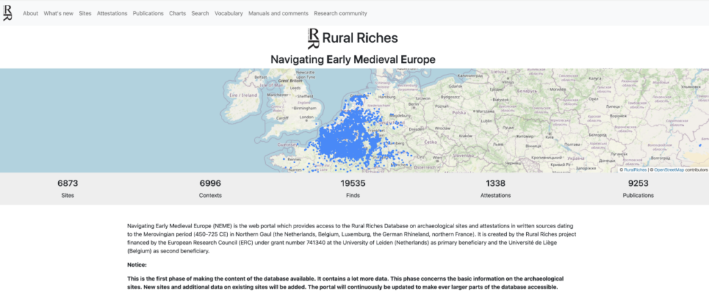
As many of you probably know, we have been working on an online database collecting archaeological sites and historical attestations dating to the Merovingian Period in Northern Gaul (450-725). Up to now we have recorded information on 6873 sites and 1338 attestations, filled the bibliography with 9250 references, counted immense numbers of beads, brooches and glass vessels, recorded the location of finds in graves, and much more. This database will be a major instrument for future research on the Merovingian period.
We have been collecting sites in this database since the start of the RURAL RICHES project, which is financed by the European Research Council (ERC) under grant number 741340. You can find more information on the project here.
Now the Rural Riches project is coming to an end, the time has come to launch the Webportal which provides access to this database. After the 9th of December, the URL will be: http://www.earlymedievaleurope.org.
The festive launch of this new research tool will take place on December the 9th at the faculty of Archaeology of Leiden University during a one-day symposium on ‘Recording Merovingians’. Speakers from abroad will present comparable initiatives in France, Austria and Germany and members of the project will present their research. The programme of the symposium can be found below.
You are kindly invited to attend the symposium and the launch of the portal. We will celebrate the launch at the end of the day with a small party. For those who cannot travel to Leiden the symposium and the launch can be followed online followed using this link: https://streams.nfgd.nl/recording-merovingians.
If you would like to join us in Leiden on the 9th of December please send an email to recordingmerovingians@gmail.com (before December 3th) with your name, affiliation and dietary wishes so we can plan lunches, coffee and tea.
We hope to welcome you all in Leiden very soon!
Frans Theuws & the Rural Riches team
Preview of database web portal
Symposium Programme
9 December 2022 Faculty of Archaeology Leiden Rural Riches Project
09.00 Coffee 09.30 Frans Theuws (Leiden University): Introduction to the project 09.55 Stephan Eichert (Naturhistorisches Museum Wien)/Nina Richards (Östereichische Akademie der Wissenschaften): Recording early medieval cemeteries in Austria (Thanados) 10.20 Mette Langbroek (Leiden University): Networks and bead research
10.45 Break (30 min)
11.15 Cyrille Le Forestier (National Institute of Preventive Archaeological Research and UMR6273, CRAHAM, University of Caen-Normandy): Recording early medieval cemeteries in the Île the France 11.40 Femke Lippok (Leiden University): Burial rites and communities of practice 12.05 Susanne Brather-Walter (Universiät Freiburg): Digital beads of the Lauchheim cemetery
12.30 Lunch ( 60 min)
13.30 Jip Barreveld (Leiden University): The whereabouts of Merovingian kings 13.55 Rica Annaert (Flemish Heritage Agency): recording Merovingians in Belgium 14.20 Roeland Emaus (Leiden University): Digital Merovingians
14.45 break (30 min)
15.15 Phillip von Rummel (Deutsches Archäologische Institut): Recording Merovingians in Germany 15.40 Frans Theuws/David Schaper (Leiden University): The Rural Riches database 16.05 Launch of the Portal by Phillip von Rummel
This blog post will share some of the first preliminary results from the ‘attestation’ database. Although the Rural Riches database is primarily an archaeological database, we decided to also include evidence from written sources. Textual evidence often provides important topographical information, for example on towns, cult places and rural estates, which can help interpret the archaeological evidence. But texts also offer the possibility to trace the whereabouts of elite individuals, such as the Merovingian kings, so that we can investigate the extent to which elites were present in our research area.
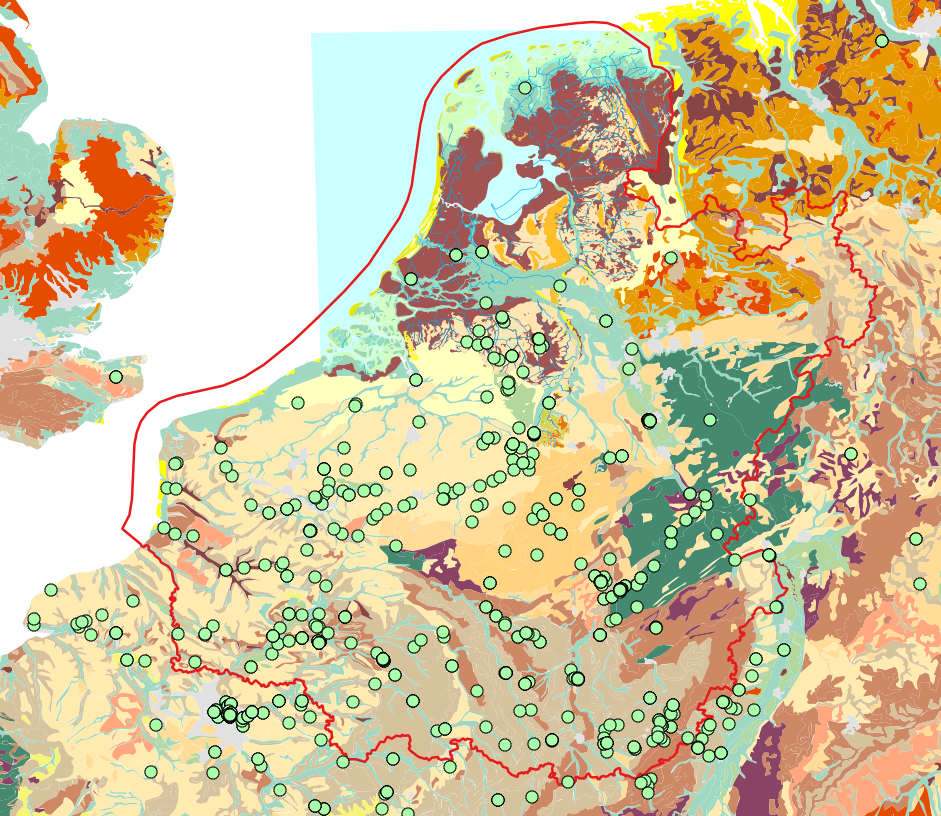
As a part of the sub-project ‘Towns and Elites’, Jip Barreveld has been mapping the itineraries of Merovingian kings between 450 and 650. But texts come with a range of problems seperate from archaeological datasets. To map textual sources and compare them with the archaeology, it is important to be aware precisely what is being mapped and what problems are present behind the dataset.
Currently recorded attestations from written sources projected on the palaeogeographical landscape. The red line represents the border of the Rural Riches research area. Attestations for royal presence have been recorded both inside and outside the research area to draw comparisons.
Attestations
Each record in the database consists of one attestation: a single piece of evidence (e.g. a few words, a line, or several lines) from a written source for a specific place that can be mapped in geographical space. With an archaeological excavation, we can usually pinpoint exactly where a spade entered the ground (especially with the help of modern GPS). In contrast, for written sources there is no direct relationship between the text and a location. Geospatial information can only be inferred from a toponym mentioned in a primary source (almost always in Latin). Philologists and historians have matched many ancient place names to modern ones with reasonable confidence, but the identification will always remain to some extent hypothetical. For this reason, attestations are kept strictly seperate from archaeological records in the Rural Riches database, although an attestation can be linked to the record of an archaeological site.
Attestations can come from all kind of written sources. Unfortunately, documentary sources for the Merovingian period are relatively rare, so we mainly rely on narrative texts, such as histories, saints’ lives or even poems.
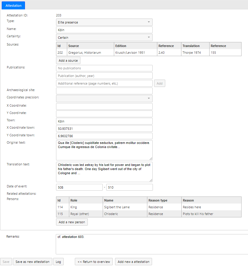
Here is an example of an attestation, from Gregory of Tours’ Histories, 2.40:
“One day Sigibert went out of the city of Cologne and […] crossed the Rhine, for he wanted to walk in the forest of Buchau” (translation by Thorpe, p. 155).
Cumque ille egressus de Colonia civitate, transacto Rheno, per Buconiam silvam ambulare disponeret … (Krusch/Levison ed.).
Two locations are mentioned in this line for the whereabouts of ‘king’ Sigibert the Lame, providing us with two attestations (one for Cologne, one for ‘Buchau’). Next to place, the attestation also provides information on who (Sigibert), what (walking or hunting) and when (c. 509, from context).
The record of an attestation with fields for coordinates, source, translation, secondary literature, text, date, commentary and more.
Interpreting place names
The first attestation, civitas Colonia, refers (almost) certainly to the modern city of Cologne. In the second attestation, Sigibert is ‘walking’ (perhaps hunting) in the silva Buconia, but its modern location is less certain. We know the name otherwise only from later Carolingian sources, as a vast forest in Hesse (Germany). Is this the same forest mentioned by Gregory, and did it stretch all the way to eastern bank of the Rhine at Cologne, or did Sigibert travel much further into Germania? All this we can only speculate.
Identifying the toponym presents the first challenge, and we must hope that the editor has correctly transcribed the medieval manuscripts, and that the manuscripts faithfully copied the ‘original’ text. Even when we are reasonably sure about the toponym, we usually do not have precise geographic information. For example, in this case Gregory does not tell us where in Cologne Sigibert was. Perhaps Gregory might even have used Cologne as the name for the whole district.
Topographic logic of the text
Archaeologists know that there are problems and gaps behind a distribution map of material culture; formation processes and excavation techniques can skew the archaeological dataset. The same is true for texts, where the surviving texts may represent only the tip of the iceberg. After all, only a fraction of what was written in the Merovingian period has survived the centuries.
On top of that, texts present a very partial picture, since the author wrote with a specific mindset, intent and for a specific audience. For example, Gregory’s narrative choices are informed by his rhetorical purpose of advancing the concept of a catholic Gaul united by the Merovingian kings [1]. He also more frequently wrote about places that personally mattered to him, his family members and network of friends and readers. It follows that we should pay close attention to the social and historical context that shaped the topographic framework of our sources, which we could call the ‘topographic logic of the text’ (after Gabrielle Spiegel’s ‘social logic of the text’).
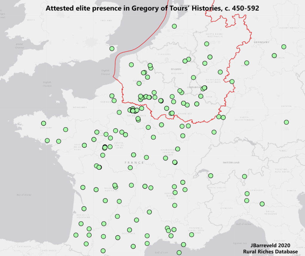
Recorded elite presence in Gregory of Tours, including uncertain attestations.
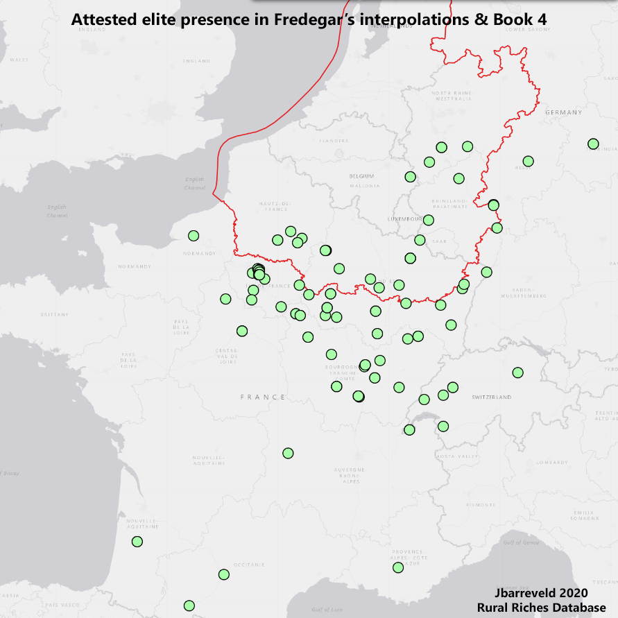
Using the database, it is possible to filter the recorded attestations by source. When we do a side by side comparison with the seventh-century Chronicle of Fredegar, a totally different distribution map appears. Fredegar’s narrative is more focused on the north and east of Gaul: the areas around Paris, Burgundy and Austrasia.
Recorded elite presence in Fredegar’s Chronicle book 4 and interpolations, including uncertain attestations.
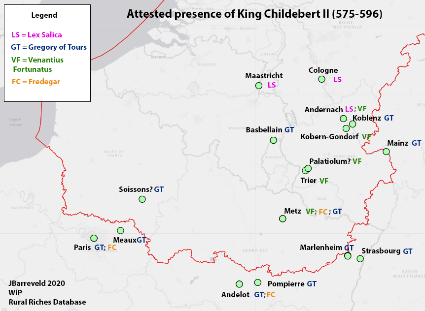
We can also zoom in on specific individuals. Using the database to plot all attestations of King Childebert’s II whereabouts, we can map his presence all over northern Gaul split by source. Gregory’s Histories (blue) give the widest distribution. His contemporary Venantius Fortunatus (green) gives a much more detailed picture of the Moselle and the Rhine valley, recorded in two poems describing a royal boat trip. Finally, the chance survival of three edicts by Childebert II as additions to the Lex Salica (pink) place the “Austrasian” king in the triangle Andernach-Cologne-Maastricht.
Without this fortuitous survival of Childebert’s decrees, we would not have had a single attestation of royal presence in sixth-century Maastricht!
Recorded attestations for the whereabouts of Childebert II, divided by source. The image is a quick sketch, the integration of GIS capabilities with the database allows for improved visualisations in the future.
What’s next: analysis and interpretation
The examples above show that textual sources give only a partial image. The scholar of Merovingian historical geography needs to carefully weigh the evidence and be aware of the possible gaps in the dataset. So what, then, can we learn from attestations? And how does textual evidence compare to the archaeology in our database? That will have to be the subject of another blog! Stay tuned for part 2.
[1] Following Breukelaar, A.H.B., 1994: Historiography and episcopal authority in sixth-century Gaul: the Histories of Gregory of Tours interpreed in their historical context, Göttingen, 207-225.
An ‘empty shell’, ‘ghost town’, or even a ‘field for pigs’. The prevailing image of the early medieval town in northern Gaul just after the collapse of Roman authority in the fifth century is one of crumbling ruins. For a long time, preconceived notions of what an early medieval town ought to look like have cast their shadow over the evidence. But new archaeological discoveries and a fresh perspective on the written sources is starting to change this picture. Here, I will zoom in on one such town: Cologne around the year five hundred.
You can read the rest of the blog over at its original publication at Leiden Medievalist Blog.
The blog post is written by Jip Barreveld for the Leiden Medievalist Blog, based on ongoing research for his dissertation on ‘Towns and elites in Merovingian northern Gaul’ as part of the Rural Riches project.
Rural Riches can now be found on Twitter! Although we love to be with our minds deep in the Merovingian past, we also recognize that sometimes it is important to catch up with modernity. With Twitter we hope to increase our public outreach and contribute to the valorization of knowledge.
We will use Twitter to bring attention to new blog articles on this website, but we will also use it independently to report on the project, the team, and the world of Merovingian archaeology at large. It should be interesting both for specialists and interested lay(wo)men alike. So, if you are on Twitter and like Merovingian archaeology, make sure to to follow @RichesRural.
If you have news pertaining to Merovingian archaeology or history that you would like to share to the world, please contact us! Both our website and Twitter are meant as a platform for research on the Merovingian world.
Source image: Jessie Daniels, ’10 Things about Twitter for Academics’, JustPublics@365